Hiking the Shabbona Trail
My longest hike of the season so far has been the 16 mile Shabbona Trail between Channahon and Morris, Illinois.
The Shabbona Trail is in the heart of the 61-mile long Illinois & Michigan Canal National Heritage Corridor.
The Chief Shabbona Historial Trail was established on July 30, 1960 by Boy Scout Troop 25. The trail is nationally approved by the Boy Scouts of American and follows the paths that Shabbona was known to have walked. By 1963, over 10,000 scouts hiked the trail. Along the trail, you will see full-sized replicas of canal boats, locktender’s house, working stone locks, and fully restored stone aqueducts.
The habitat ranges from open prairie grasslands to dense woods. The Illinois River provides panoramic views in many areas. The trail is shaded in most areas by a variety of trees including walnut, oak, ash, maple, sycamore, hawthorn and cottonwood. You also see beaver, muskrat, mink, raccoon and deer from time to time.
Channahon State Park (Trail Head)
The Channahon State Park is the official trailhead of the Illinois & Michigan Canal State Trail. It became a state park in 1932, one year before the canal officially closed. During the Great Depression, the Civilian Conservation Corp restored Lock 6, Lock 7 and the Locktender’s House.
McKinley Woods (Mile 3)
McKinley Woods is a 525-acre preserve operated by the Forest Preserve District of Will County. It is a diverse habitat of forest, prairie, wetland and riverfront. It is a favorite site for bird watchers, kayakers, and geocaching enthusiasts.
Dresden Lock (Mile 6)
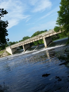
The Dresden Lock is one of the most impressive man-made features along the Shabbona Trail. Listed on the National Register of Historic Places, the lock and dam complex includes an arced gravity dam, a spillway, nine Tainter gates, 18 headgates, and a section of fill dirt connecting the headgates to the embankment of the canal.
Aux Sable (Mile 8.25)
The Aux Sable access point contains three pieces of history right in the same area: Lock 8, the Locktender’s House, and the rebuilt Aux Sable Creek Aqueduct.
The Illinois Department of Natural Resources maintains a primitive camping ground for approximately five tents. There is water and restroom facilities within walking distance.
Evergreen Cemetery (Mile 13.5)
Shabbona was a member of the Ottawa tribe before he became a chief within the Potawatomi in the 19th century. He died in Morris in 1859 at the age of 84. This granite boulder was placed on his gravesite in Evergreen Cemetary in 1903.
Stratton State Park (Mile 15.5)
Named after an Illinois governor, the William Stratton State Park was developed in 1959 as a boat access to the Illinois river.
Nettle Creek Aqueduct (Mile 16)
This may be the only time I get to see this aqueduct. Originally built in 1847, the state intends to demolish and remove both the bridge and aqueduct after a flood seriously damaged the site in 2012. I wasn’t able to get a good photo because the place is a real mess.
Gebhard Woods State Park (Trail End)
Because the Nettle Creek Aqueduct was destroyed, I could not make it to Gebhard Woods.
The park belonged to the Grundy County Rod and Gun club, who purchased the land from the Gebhard family in 1934 for $1,500. The Rod and Gun Club developed a fish rearing pool on the property before donating the land to the state a few years later.
Distance: 16.51 miles
Total Time: 5:45
Average Pace: 21:15


A hike and also catch fish, thanks KC4LMD
I wished that I had time to fish. If I made it a two day hike, I would have had great opportunities.